Showing posts with label Mountain Bike. Show all posts

Monday, July 6, 2026

About Old Gear Singletrack (mountain bike)

If you visit the msptrails.org page you will see a ride calendar for Twin Cities singletrack (mountain bike) group rides and a a link to a Messenger Chat Community for ride notifications and details.

One of the rides listed on the calendar is the new (6/26) "Old Gear Singletrack" (OGS) ride that I typically lead.  It's called "Old Gear" because these are daytime weekday rides and I'm old and retired.

For the OGS rides the calendar should always have the latest information - including cancelations for weather. Join the Messenger Chat Community for ride announcements, ride changes, and communication about rides.

Saturday, May 6, 2023

Utepils BrewPub Sunday Rides

In our weird post-web post-blog world Utepils brewpub (225 Thomas Ave N #700, Minneapolis, MN 55405) ride information is only available on a Facebook group. They do a ride most Sunday mornings weather permitting. The groups may vary depending on rider volume and leader availability but there's usually a Rec level group for both road and singletrack. In winter there are often 2-3 groups for fat bike rides.

Here's the Facebook description as of May 2023, emphases mine.

As you can see below, we are putting where each ride will be gathering in the parking lot prior to each ride. This will help alleviate the joy of everyone trying to cross paths with their bikes as each ride departs.

We are implementing a few new rules this year. No Burleys, trailers, or pets on rides this year except for the designated Burley rides we will be doing occasionally throughout the year. The groups are getting too big and it creates a difficult environment to maintain. Cargo bikes are allowed and in Rec ride only. If bringing a kid in a cargo bike, please have an enclosed seat for the child. E-BIKES: Only ride in a group you could normally ride in/be comfortable in with a non-motorized bike. E-Bikes allow any rider to jump into any one of our rides. But that does not mean the rider has experience with a paceline or comfort with reaction times. Helmets always required!

PARKING: If you are driving in, please park on the street or in the upper lot nearest Glenwood and bike down to the parking lot. Between yoga also starting at 10am and the brewery opening at 11am, there simply aren't enough parking spots.

BIKE PARKING: You are always ok bringing your bike back to the patio if you do not have a lock/ability to store your bike in your car after the ride. However, we cannot lean then against the fence and block the rear walkway anymore. Utepils is instructing us to bring our bikes to the back of the patio in the lower bowl area and park our bikes back there.

Key info:

Meet at Utepils Brewery at 9:45am

Announcements start at 9:55am

Rides begin at 10:00am

Waiver link (must be signed once per calendar year): 

ROAD RIDES

Sport (Bay 1): 20-21 mph paceline with minimal stops. 30-35 mile route

Sport Light (Bay 3): 18-20 mph paceline with minimal stops. 25-30 mile route

Sport Ultra Light (Bay 5): 16-18 mph paceline with a few stops. 20-25 mile route

Rec (Parking spots nearest tracks): 11-14 mph group ride. 15-20 mile route

MOUNTAIN BIKE RIDES

Sport: Have experience mountain biking and can handle majority of obstacles in Theo/Loppet trail systems

Sport Light: Know what you are doing but not trying to set any speed records

Rec: Newer/want to go at a more casual pace. Comfortable on some obstacles

Wednesday, August 24, 2022

Sherman Lake and Rice Creek Chain of Lakes singletrack (near Lino Lakes)


The above image shows both the Rice Creek and Sherman Lake singletrack trailheads and some parking spots. The Centerville Boat Launch parking comes with a $7 vehicle fee.

These trails were new in 2022. I did them with some young novice riders and they worked well. The overall system is larger than it looks and mixes a new modern flow trail area with legacy singletrack and many bandit trails. As of May 2023 they are not yet in Trailforks but the Sherman Lake section is in MTB Project, they have a MORC page (I think map is from MTB Project so only shows Sherman Lake today), a Trailbot entry as "Rice Creek Chain of Lakes" and a Facebook Page. There's a Facebook Group for volunteers.

Now Bikes (Arden Hills?) runs a semi-regular Sunday morning ride from the Rice Creek Elementary parking lot (The pedestrian bridge is technically closed for repair summer 2023).

Trail info: https://www.alltrails.com/trail/us/minnesota/rice-creek-chain-of-lakes-mountain-bike-loop

Description: https://www.anokacounty.us/DocumentCenter/View/21084/Rice-Creek-Single-Track-Trail

"many miles of trails in at least five different nodes of the park. The trails are heavily wooded and surrounded by lakes. There are sections where biking or hiking on paved trails is required to get to the next node."

Official trailhead per Google Maps: 45°09'47.7"N 93°06'16.4"W. I've never parked there however.

We park at the Kelling woods: 45°9′48″ N  93°6′43″ W entrance. Follow the old dirt road past the closed gate (to keep out cars) and go straight on. It's a pleasant fun trail that branches to some bandit trails but keep going straight and come out on the paved trail. Turn left and in a short time you come to a purpose built system. It's flowy and loopy with some good starter climbs. I recommend two laps. Although it's a green novice trail it does have an optional gap jump!

If conditions are dry you can park just a bit to the west at the Rice Creek Canoe Launch. There's a winding trail that will also take you to the formal system. I actually prefer this route but it's often quite wet and even underwater in places. So only good on dry days.

Some comments from a 2022 Facebook post:

There is another terrain park on the other side of the golf course. Following what is labeled as F Street on the map (actually all bike trail), the other terrain park is between Centerville lake and Sherman lake. There are also 5 single track trails between the 2 terrain parks. I make a loop from my house to hit the 7 features and takes about 1.5 hours, about 12 miles.

And a map from the same post by David L (ride recording)


Update 6/15/2023 from a Facebook thread:

Sean Berry (trail steward):
The Rice Lake Singletrack can be accessed from Aqua Lane, riding the paved trail south to the trail entrance on your left, which is well marked and has a gate and signage. If you get to the long pedestrian bridge, you’ve gone too far south.

You can also access it by going north from Rice Lake Elementary School (575 Birch St, Lino Lakes, MN 55014), over the pedestrian bridge, and another quarter mile or so north: it would then be on your right

Anonimo M:

... park at Laurie Lamotte Park, plenty of parking and easy to get to from 35e. Follow the paved trail around to the Sherman lake trails (0.6 miles) … take the bandit trails to the other trails by Aqua lane.


Update 9/17/2023 - Sherman Lake

Today a friend and I got to the Sherman Lake trail. We parked at the boat launch; there's a $7 vehicle charge to enter the park but entry is free on a bike.


The coordinates of the trailhead are: 45°09'24.3"N 93°04'05.5"W, https://maps.app.goo.gl/AKzdeEib8byWsPjD8.

The trail is about 1.8 miles and it's now my favorite child and novice trail in the metro. The pine forest smells great, looks great, and has a nice view of one of the lakes. It's a flowy trail that's well maintained and fun for anyone to ride but especially inviting to beginning riders. My next novice recommendation is the neighboring Rice Creek singletrack. Then Carver in Woodbury and Salem Hills near Inver Grove.

Friday, May 20, 2022

The MSP Mississippi river bottom trails

(First published 2015, updated May 2020 and May 2022. I haven't updated all of the original text, but check out the 2020 map links at end.)

Just a quick orientation note on the rather confusing system of interrupted mountain / gravel bike / trail running system more or less along the Mississippi river north and south of I 494. More to come later. For this orientation I’m using River coordinates — so imagine river actually runs N/S and, going N, the left side is always the West bank, right side always East bank. Part of the confusion surrounding these trails is some people use compass north/south and some use river coordinates.

Fort Snelling State Park doesn’t easily connect to the trail system, there’s a large gap on the west bank due to airport and military zone that’s unlikely to close, to connect you need to climb the bluff and take the I-494 walkway trail to get to the East bank.

From Upper Fort Snelling (or lower park if climb) you can take Mendota bridge to trail that runs along East bank from Sibley House south to 494 (confusingly called the Fort Snelling State Park River Bottoms trail, but it’s easiest to get to from Fort Snelling proper, not the lower State Park or to cross the river to Sibley House area.)

A mile or so south of Fort Snelling State Park (you can’t get there thanks to restricted military/security zone), on the West Bank, south of 494, there’s a state park visitor center. From that you can do a loop along west bank that crosses at 77 to east bank and returns on 494 — this includes par of the east bank trail. (There used to be an unofficial way to get from near this visitor center to the next trail south on west bank, but I don’t know if that works now.)

From Old Cedar Ave (9500 Old Cedar Ave South, 55425) you can connect up with 2 trails on the west bank, one runs north, the other south. This is often called the Bloomington Ferry Road Access Point or “west end” (it’s on west bank) entry point, and this is the trail MORC describes as “Minnesota River bottoms” (though it’s really just one segment).

As of May 2020 more frequent flooding has made the trail sandier. Some stream crossing have been washed out or are out for repair (including the famed raft).

See also:
Update 2020 from a Facebook Group post:
Update 2022

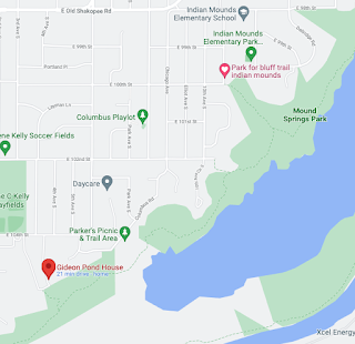
A 17-18 mile segment that leaves from parking near Gideon House. It's a relatively new park in 2022, not even well labeled in Google. Has great parking until 10pm. In 2022 the raft is in great shape.


Friday, April 22, 2022

St Paul Gravel Rail Trails

These take advantage of some gravel along rail trails and some sandy trails. It's a route for wet weather or other conditions where we can't ride dirt. 

The reference St Paul gravel trail. It's about 25 miles.

The one I did because a train blocked part of our plan. About 22 miles.


Tuesday, March 29, 2022

Minnesota River Bottoms paved loop: 35W to 77

There's an emerging paved loop along the MN River Bottoms that can be a good option when dirt trails are too wet to ride. It's possible that one day it will be a good option for inline skating, but as of 2022 I think some parts are too rough or even gravel.


The above screenshot is taken form a RideWith GPS River Bottom route. If you part at the Lyndale lot by I35W bridge you head on paved trails along the MN river. Stay to the right, the fun dirt trails go left to the bluff. Trails run into the MN 77 bridge and that has a bike path that will go across the river. On the other side going downstream there's the dirt trail to Sibley House, but upstream there's a paved trail to 35W. Cross back on the 35W bike trail to the Lyndale parking.

Beyond 35W upstream is an industrial area, I don't think there's any way to cross it.

I think the paved trail extends beyond the MN 77 bridge on the north side of the river, so there's an out and back option there to extend the ride distance.

I hope to update this post with my tracked ride.

Sunday, February 20, 2022

Bandit trails of Utepils Brewing

Utepils Brewing is a truly excellent brew pub, north Minneapolis landmark with a lovely view of a stream and an active bicycling community - singletrack, road and fat.

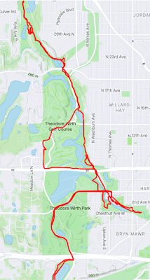
When nearby Theodore Wirth trails are closed the trail rides explore a surprising range of dirt options. I'm going to try to collect a few Strava Maps for posterity. The winter fat bike "bandit" trails are among my favorites -- even more than the superb trails at Theodore Wirth park.

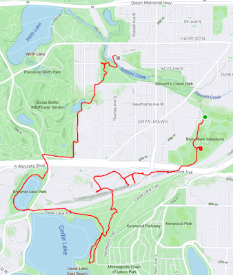
Summer ride along rails (click to enlarge) ...


There are some fun paths that go by a school in here. Cross a few rail lines.
The Cedar Lake East beach is a well known Bohemian beach (bare butt), I think there's one on the east side of Wirth Lake too but that's not for olds.

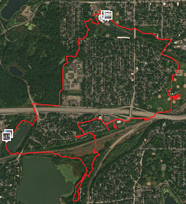
Variant of above but satellite view. 
The dense square is a skills park.
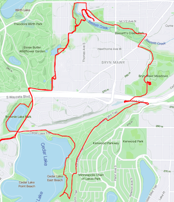
And slightly better choice

Wednesday, April 7, 2021

Cross West St Paul: Kaposia Landing to Brickyard Trail

In a previous post I described the excellent Harriet Island (Paddleford Landing) to Kaposia Park via Robert Piram trail route:


This route describes a pleasant and relatively car-free route across West St Paul to make a loop that's between 11-13 miles (depending on variations). A google maps link should produce something close to this image:


The above route is about 3.8 miles and involves some big drops and climbs, there's a direct route that has only modest climbs and drops and is 2.7 miles:


If you're riding a mountain or fat bike there are some adventure options in this detail view:
Just after crossing over the freeway on the bridge from Kaposia Park there's a quick dirt trail drop onto a multi-use path. Follow that on a mountain or fat bike and you end up at Thompson Park Lodge.

On a road or mountain bike you can take a fast curvy trail deep into the very obscure Bluff Terrace Park shown at the top of the above detail (map).

Also on a mountain or fat bike when you get Brickyard Trail at the left side there are some interesting options:
In particular on a trail bike you can take the steep fast Brickyard trail to the bottom and find your way to Lilydale bike trail (don't take the railroad track, take the trail out) and then back to the Harriet Island Paddleford Landing start. At first you may think this trail is firmly fenced away (for some reason), but follow the fence to the right to see where locals have opened an entrance big enough for a small car.

On pavement follow the bike path on Cherokee Heights Road over to Ohio street and down to Paddleford that way.

Wednesday, November 25, 2020

Minnesota River Trail - The River Bottoms from Indian Mounds to 9 mile creek crossing (Long Meadow Lake Unit) + Bloomington to Mendota extra

(From 2015, republished 2020 since it's had some updates but it's not all current. There are updated to 2020 map links in another 2015 post.)

The Minnesota river trail is going to change. Major parts will become a paved trail. This means a lot more people will appreciate the river, but the trail many love to run and ride is going to change.
So I’m glad Ben and I got to ride some of the best parts — on a sunny and pleasant November Saturday.

The trail we took is part of a large system along the Minnesota river (save JPEG locally to view). Our Long Meadow Lake section is at the top left of this map:
RiverBottomNov2015 5
Basically we did the bottom half of the Long Meadow Lake Unit Trails. Note the blue in the picture below. That’s important! If you end up on the wrong side of the marsh you can’t get back to your entry point. So be careful, the trails are not well marked!
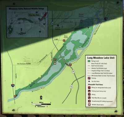
RiverBottomNov2015 6
The MORC trail map Google Version provides the best overview for a mountain biker:
MORC map
For Minneapolis and Saint Paul residents the traditional approach to the trail is to take bikes on light rail to the Mall of America, then ride a short distance to the yellow/orange entry trails towards the upper right of the screenshot (enters near Bass Ponds Parking, 44.845976, -93.232640). [Update 2022: I think to do this you'd need to ride through the bird sanctuary! I doubt that actually bothers the birds but we aren't allowed to do that.]

Unfortunately Center Point Energy is replacing a natural gas pipeline along the “bluff trail”, so we entered at the Blue “A” icon by Mound Springs Park, just south of Indian Mounds Elementary (11th Ave S, 44°49’23.6”N 93°15’33.1”W). From there we road to 9 mile creek, marked by the blue sailboat icon. You can see our route on Strava.
Strava
The Minnesota Valley Long Meadow Lake Unit Trail Map is a good guide to other entry points. The Old Cedar Ave parking area on that map, unfortunately, is cut off by construction. We really entered at the best site available today. From this point downstream the trail is closed.

It’s easy to park on the street by the entrance here — there’s lots of room in November. There’s a sign saying  you can also park at the school nearby.
RiverBottomNov2015 17
From this point the trail descends smoothly and joins a creek. We stayed to the left at the first fork…
RiverBottomNov2015 16
When you’re zooming down it’s very tempting to just try to run a rock pile put in place to manage erosion. These are not friendly rocks. They are rough concrete irregular slabs that are very painful to land on. I recommend walking.
RiverBottomNov2015 15
That’s about it for the tricky part of this entrance. The trail is pretty easy to pick up further down the stream.

The trail has lots of forks and branches; heading upstream there are many entrance trails joining from the right. These can be confusing on the return — it was useful to be using Strava so we could retrace our trail. Parts of the trail are narrow and seem almost natural — I bet this was an Indian walking route once. There are also bridges and ramps and wood sections, some very old and some brand new. There are concrete and steel picnic tables in the woods that could be 30-40 years old.
It’s a multi-use and bidirectional trail, so be extra-polite to walkers and runners and watch for oncoming bikes. It’s very pretty in the Fall, and presumably year round …
RiverBottomNov2015 13
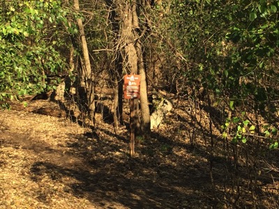
I think this might be the treacherous trail branch point a friend warned me of — go right and there’s no way back to where we started from “On the return, where the the blue/green trails split, there is a critical branch. If you miss this turn on the return route - easy to do if you ignore the trail going left away from the river and continue straight - you will NOT be able to get back to where you started from”.

You’ll come across this when you return, not long after reentering from the parking lot by 35E.
RiverBottomNov2015 4
The Long Meadow Lake Trails end at 35W. But don’t stop there. Continue along the river, following a dirt service road. If you stay by the river it turns back into a trail. After a mile or so you come to one of the gems of the Twin Cities —- the famous 9 mile creek crossing:
RiverBottomNov2015 8
As you can see there are two ways to cross. One is by raft, the other, upstream a bit, is by tree trunk with added steps: [In 2020 this was lost years ago - tragically removed by bad people.]
RiverBottomNov2015 10
Yes. Someone did this. Presumably many someones. The raft is a serious piece of well maintained kit with heavy ropes. I don’t think it’s Fish and Wildlife, though they must tolerate it. It’s a legend and one must bow in respect. I took the ferry over the creek then carried my bike over the tree. I know people who ride the tree and rails, but I do not think I will ever have those skills.

Then we headed back. Next time I’ll do more loops, this time I used Strava to confirm I was retracing my route correctly.

I’m looking forward to going further next time. In winter there are Fat Bike meetups along this trail…

PS. When I was putting this blog post together something caught my eye where the stream we entered by meets the river:
Swimming hole
That little round circle, on close magnification, may have a sort of jumping board on it. I think it’s a local swimming hole…

Update 5/24/2020: I added some modern maps to my 2015 post on the river bottoms. They really help out.

Update 11/25/2020: Further downstream, at the Nature reserve by 494, you can take the 494 bike path over the MN River and across Gun Club Lake, then on the south side of Gun Club take a dirt path exit and double back over the lake under the bridge and catch the Mendota Trail. Some images here from Facebook, and a description from there that I've edited a bit ...

If you're coming from Bloomington you first take paved 494 bridge ped/bike trail over the MN river until the concrete bridge bridge railing ends. It's not marked but at that point you can see a well worn dirt path entrance. There's a short relatively steep and a bit rocky drop (easy to walk if you prefer) then an easy broad trail that turns into a dirt access road. The path goes under the bridge, then it curves back along (under) the edge of the eastbound 494 elevated roadway. You proceed to ride under the edge of the bridge until you get to the MN River channel, and then turn left (to Cedar) or right (to Mendota).


Update 2/21/22: In the above I entered by Indian Mounds school. Another place to enter is by Gideon Pond House (below). The later option can be good if one is going to ride past 9 mile creek all the way to Bloomington Ferry and you need to shave a bit off the route.


Sunday, May 24, 2020

A 26 mile mountain and road bike minneapolis ride

I haven't done this ride, but sharing it for future reference from a Facebook river bottoms group.

Some times the river trail will be underwater in places.


Thursday, August 8, 2019

Sunday Ride - Murphy Hanrahan (Murph)

Murph is a western metro trails system with a xc flavor.

Parking is by the trail head: 44.724184, -93.348320, 44°43'27.1"N 93°20'54.0"W.

Three Rivers publishes a trail map, and it's well represented in mtb project. Trail status is published on the MORC page and the Murphy Hanrahan MTB Facebook Page. MORC volunteers maintain it.

All the trails connect, so start on easy, go to intermediate, then do advanced.

Friday, June 28, 2019

Sunday Ride - road to Carver Lake Park, Mountain Biking, return

This Sunday ride combines a road ride with mountain biking and possibly including trials of some Pivot mountain bikes.

On June 30 Angry Catfish and Pivot Bikes are providing loaner bikes from 10am to 4pm at Carver Lake Park. So there's the option of riding a road bike to Caver and then borrowing a mountain bike. Carver is sometimes used as an introductory trail for someone new to mountain biking (trail riding really, we don't have mountains here).

I'll ride my mountain bike so I won't use up a trial bike, but if one is free I'll try it. Since I'm on my mountain bike I have an excuse for being slow.

The ride starts in St Paul's Mac Groveland neighborhood and looks something like this:


There's about 30 miles of road riding plus Carver trail biking. I think we can get lunch in South St Paul (Stockman's Truck stop) but bring some snack food and water.

There is a possible variation: if everyone is on mountain bike we could take a shorter route by doing the Battle Creek overlook trail down to the bottom of the creek, and then pickup the road and trail along highway 61.

On the way back we'll climb Ramsey Hill (much nicer than climbing Jefferson) or follow Tim around Cathedral to Summit.

Sunday, September 16, 2018

The St Paul Traverse road and mountain bike trail

Duluth has the amazing Duluth Traverse trail that ties together several mountain bike trails. Even that trail has some road connectors though. It occurred to me that there’s a natural St Paul “Traverse” trail that connects anything along the river with Battle Creek and Carver. It’s most paved bike trails or single track with a bit of quiet road.
Here’s the overview and the Carver MTB component:
BC to Carver
Here’s the section from the NE end of Battle Creek (technically NE end is not in park, it's Scenic Overlook)

The area circled in red is where I’d prefer to jump out of BC onto the paved trail. This is at the base of Goat Trail (not a beginner trail!), from the satellite map close up it looks like one could descend a grassy area to the paved trails (see footnote [1]). The map below is from mtbproject (REI).

BC

This would be a solid day of road/single track riding for most of us!

Update 6/9/2019  - more detailed version for a Sunday Ride

Depending on our timing a few segments can be dropped. There aren't a lot of places to stop and eat until the end of the trail. This ended up being a bit over 30 miles but it felt like 50-60 riding my mountain bike, doing the trails, and a surprising amount of up and down.

Segment 1: Groveland Tap to Overlook 8 miles

Segment 2: Batttle Creek Overlook to exit point (mtbproject)
The red line is the path overlaid on the mtbproject map. I think this is probably about 5 miles. The exit, is as above, not official. Will be bushwhacking (see footnote [1]).

This is St Paul East Side. The "Boys Totem Town" is a 100yo correctional facility for youth. It is to close in July 2019. (When we rode this in Strava you can see where we took a wrong turn or two.)

Segment 4: From start of Battle Creek back to the trails
The lower right quadrant here are trails we ski in Winter. This segment also appeared in an earlier post. The top right quadrant is Battle Creek Water Park, there can be ice cream trucks there and there are bathrooms. From here you can see wetlands Battle Creek runs through, but it starts in Battle Creek Lake in Woodbury (I think it is underground until it emerges near the water park).

When we actually rode this (Strava, below) we missed turning left on Upper Afton Road so instead of taking Battle Creek Road to the trails we followed Creek back to Luge Connector. (Battle Creek goes underground again at the end of the park to pass beneath rail and freeway.)

Segment 5: From S Battle Creek Road pick up the trail to Bowl and Luge to Overlook

8.3miles, 55 minutes. There are many eating options here at the end.


And here's how it looked on Strava with a few false turns, about 30 miles (felt longer):


- fn- 
[1] We were able to transition from the segment of Goat to the paved bike path -- but it's not easy. There's only one place to transition and it's fairly steep. We were able to walk it down using the bike partly as an aide -- but only because invasive vegetation had been cleared and it was opened up a bit.


Battle Creek Mountain Bike Trails

[This post has been updated several times since 2018. The more recent maps and links are at the bottom.]

Battle Creek (county trail map, better mtbproject map) is St Paul's mountain biking trail. It’s not only a great trail, it’s accessible by bicycle trail from many directions. Battle Creek MTB Facebook Page: www.facebook.com/battlecreekmountainbike

My preferred starting points from western St Paul:

Driving to start: Point Douglas Rd S parking lot.  Turn east off Hwy 61/10 on Lower Afton Rd, then go north on Point Douglas Rd S to the parking lot at the end of the cul-de-sac. (44°56’07.5"N 93°01'42.8"W).

Riding to start:  Scenic Overlook by Burns Avenue and Hwy 10: 44°56’48.2”N 93°02’19.3”W  This small park with the hidden entrance isn’t technically part of Battle Creek. I’ve been told it’s Ramsey county land and not policed by SPPD. In the past few years it’s had more drug trafficking and is not a great place to park or to be at after dark so I park near Obb's sports bar and cycle over. [5/22, parking is closed there now, but see below for how I start there.]

Update 4/9/2020 - A Facebook post updated notes and a link to the 4/2020 high res map. See also the author's site version.  The 28MB geoPDF version of the map conforms with geoPDF standards, if you import into Avenza.app or similar apps you can see your location on the map.

For me the "Wall of Death" is in a class of its own (I avoid it).


From the Facebook post:
1) Travis’s Trail is one-way, away from the Overlook. This is not optional. If you see someone riding it backwards, please use this statement “the Trail Steward has asked us to remind wrong way riders to ride the correct direction. Thanks for turning around. No, I’m serious, he doesn’t care who you are. Don’t make me call him!”
2) Jesus Saves is the entrance to the North Rim area, not Dingo
3) Lower Dingo is two-way to allow you to get back to the Chute. Dingo is one way downhill. Do not go up Dingo. You are asking for a head-on collision
4) Luge is one way downhill. The Hump to Cop Out is the shortest return if you want to session Luge. Do not ride or push up Luge. Not even the center. Seriously. I’m talking to you, guy on the 26” Mongoose w/out a helmet...
5) Cop Out (located at top of the Hump), Turkey Trot (shortcut between Overlook and Travis’s Trail), Luge Connector (left at bottom of Luge), and The Narrows (straight at end of Luge Connector, takes you to start of the Hump) are not individually named due to space limitations
Chong Xiong marked up a different map with his (long) loop sequence. He starts at the Rec Center.


In a 4/28/2021 Facebook post Andrew Hovel shared a great orientation to BC:

I think of Battle Creek in 4 sections, and as a general rule, think of the most eastern point as "12 o'clock." You will USUALLY be traveling counter clockwise (with Overlook area being the opposite) 
 
1) Overlook trails (connector from Dingo to Pt Douglas, Overlook, Travis's)
2) East of the Valley (Jesus Shaves, Ski Jump, Dingo)
3) West of the Valley (WoD Luge, Freight Train - all  clearly downhill; The Hump, Wheezy - smooth climbing trails, Picnic Loop - this one traverses)
4) Ski Trails area (Goat, Fern Gully, Pines Climb & descent, Warm-up Loop etc)

Most of the climbing or downhill oriented trails should be pretty clear which direction is correct. Most of the others are well signed at points where you exit a connector road or a ski trail. If you are entering one from one of those points, and you didn't see a carsonite sign with a Green/Blue/Black indicator, there's a good chance you're going the wrong way.

Some two ways and ski trail junctions cause confusion
-BC Road connector (from WoD to BC Road)
-From Dingo & the Chute / Pt Douglas parking lot to Old Pt Douglas Road
-Return climb to Goat - a good chunk of this is on a ski trail as opposed to single track

I still get totally lost about the warm-up loop area. 
Proceed with caution when you aren't sure which direction or if a trail is two way.

As of 5/2022 below is one of my favorite approaches to BC (ridewithgps) The overlook is closed to parking (it was a high crime area), I park on a residential street not far from Obbs. Feels safe enough.

See also

Saturday, May 26, 2018

Lake Elmo Park Reserve: Big Bluestem and Eagle Point Mountain Biking Trails

This post was written for a group outing so it’s not a typical trail review.

Introduction

Lake Elmo Park Reserve has two multi-use trails suitable for novice trail biking (trail maps.pdf). The trails can also be used in winter for skijoring. Both trails have some horse traffic (see below) and can be ridden in both directions. They resemble old country roads.

The Big Bluestem trail is 2.5 miles. It is pretty flat and quite pleasant with some shade (blue trail below)

The Eagle Point Lake trail is a 3.8 mile loop (red trail below). It has a bit hillier and less shaded than Bluestem and has more horse traffic.  There are areas where rainwater can collect.

In addition to these two trails there are unnamed side trails (purple dashes on trail maps) that can significantly extend rides and connect loops. Grass is longer on these trails.

LakeElmoParkReserve

Location and Fees

When you enter the reserve from the south park at the first lot on the left. You can use copy/paste these coordinates in your phone for the parking lot:

There is a $7 vehicle fee ($30 a season).

Here’s the trailhead, we will take the blue trail to the right

LakeElmoParkReserve1

Things to bring

  • Helmet. Every rider needs a helmet including ride leaders, aides, etc.
  • Bike: A mountain bikes best. A gravel, “cross” or “city” bike would work for a more expert rider who could manage bumpiness.
  • Cell phone for aides, ride leaders
  • Good ideas: water, sunscreen, tic repellent spray for legs

Meet-up procedure

  • Everybody text john with their name and rider info
  • Mechanical bike check: ABCD
  • Gear: set to low gear
  • Skills check: braking
  • Ride guide: 1-2 groups, wait at trail branch (can ride back to trailing group)
  • Pedestrians and Horses have right of way
  • Horse orientation
    • Pass from behind: call out in friendly voice from a distance, rider will provide passing room
    • Pass from in front: I think is best to stop pull over to the side and let horses pass. 

Plan

  • Ride the “Big Bluetstem” (it’s not very big!): 31, 30, 29, 28, 27, 25, 24, 23, 22, 27, 28, 29, 30, 31
  • If everyone wants to do more we can repeat or do Eagle Point
  • If need to cancel (Rain, Temp over 95F) will send to MNSH Group and will update Facebook Event.

Notes

  • There is some horse poop but it’s not minor at this time in season. 
  • There are minimal horse flies that a rider can run into
  • Some of the trails are not well shaded, so wear sunscreen and drink water
  • The Eagle Point Lake trail can have standing water after a downpour
  • The trails we are on are not overgrown, but there are ticks in the taller grass. Consider spraying lower legs.

Some trail photos

The bicycling is generally easy but novices may need to walk up a few steeper hills

LakeElmoParkReserve5

When we come up on horses call ‘hello’ in a friendly voice, let rider move horse to the side. If approaching from the front pull over and let pass unless rider says otherwise.

LakeElmoParkReserve4

It’s pretty …

LakeElmoParkReserve3

LakeElmoParkReserve2