My skijor girl is too elderly and arthritic for this season, but I was happy to learn that Bunker Hills Regional Park has a skijoring trail: “Over 8 kilometers of groomed trail meanders through the oaks, pines and prairie in the western portion of the park”. They have rental skis too.
Tuesday, November 27, 2018


Sunday, September 16, 2018
The St Paul Traverse road and mountain bike trail
Duluth has the amazing Duluth Traverse trail that ties together several mountain bike trails. Even that trail has some road connectors though. It occurred to me that there’s a natural St Paul “Traverse” trail that connects anything along the river with Battle Creek and Carver. It’s most paved bike trails or single track with a bit of quiet road.
Here’s the overview and the Carver MTB component:

Here’s the section from the NE end of Battle Creek (technically NE end is not in park, it's Scenic Overlook)
The area circled in red is where I’d prefer to jump out of BC onto the paved trail. This is at the base of Goat Trail (not a beginner trail!), from the satellite map close up it looks like one could descend a grassy area to the paved trails (see footnote [1]). The map below is from mtbproject (REI).

This would be a solid day of road/single track riding for most of us!
Update 6/9/2019 - more detailed version for a Sunday Ride
Depending on our timing a few segments can be dropped. There aren't a lot of places to stop and eat until the end of the trail. This ended up being a bit over 30 miles but it felt like 50-60 riding my mountain bike, doing the trails, and a surprising amount of up and down.
Segment 1: Groveland Tap to Overlook 8 miles


When we actually rode this (Strava, below) we missed turning left on Upper Afton Road so instead of taking Battle Creek Road to the trails we followed Creek back to Luge Connector. (Battle Creek goes underground again at the end of the park to pass beneath rail and freeway.)


Here’s the overview and the Carver MTB component:
Here’s the section from the NE end of Battle Creek (technically NE end is not in park, it's Scenic Overlook)
The area circled in red is where I’d prefer to jump out of BC onto the paved trail. This is at the base of Goat Trail (not a beginner trail!), from the satellite map close up it looks like one could descend a grassy area to the paved trails (see footnote [1]). The map below is from mtbproject (REI).
This would be a solid day of road/single track riding for most of us!
Update 6/9/2019 - more detailed version for a Sunday Ride
Depending on our timing a few segments can be dropped. There aren't a lot of places to stop and eat until the end of the trail. This ended up being a bit over 30 miles but it felt like 50-60 riding my mountain bike, doing the trails, and a surprising amount of up and down.
Segment 1: Groveland Tap to Overlook 8 miles
Segment 2: Batttle Creek Overlook to exit point (mtbproject)
The red line is the path overlaid on the mtbproject map. I think this is probably about 5 miles. The exit, is as above, not official. Will be bushwhacking (see footnote [1]).
Segment 3: Exploring a curious neighborhood (2.7 miles)
This is St Paul East Side. The "Boys Totem Town" is a 100yo correctional facility for youth. It is to close in July 2019. (When we rode this in Strava you can see where we took a wrong turn or two.)
Segment 4: From start of Battle Creek back to the trails
The lower right quadrant here are trails we ski in Winter. This segment also appeared in an earlier post. The top right quadrant is Battle Creek Water Park, there can be ice cream trucks there and there are bathrooms. From here you can see wetlands Battle Creek runs through, but it starts in Battle Creek Lake in Woodbury (I think it is underground until it emerges near the water park).
When we actually rode this (Strava, below) we missed turning left on Upper Afton Road so instead of taking Battle Creek Road to the trails we followed Creek back to Luge Connector. (Battle Creek goes underground again at the end of the park to pass beneath rail and freeway.)

Segment 5: From S Battle Creek Road pick up the trail to Bowl and Luge to Overlook

8.3miles, 55 minutes. There are many eating options here at the end.

And here's how it looked on Strava with a few false turns, about 30 miles (felt longer):

- fn-
[1] We were able to transition from the segment of Goat to the paved bike path -- but it's not easy. There's only one place to transition and it's fairly steep. We were able to walk it down using the bike partly as an aide -- but only because invasive vegetation had been cleared and it was opened up a bit.
Battle Creek Mountain Bike Trails
[This post has been updated several times since 2018. The more recent maps and links are at the bottom.]
My preferred starting points from western St Paul:
Riding to start: Scenic Overlook by Burns Avenue and Hwy 10: 44°56’48.2”N 93°02’19.3”W This small park with the hidden entrance isn’t technically part of Battle Creek. I’ve been told it’s Ramsey county land and not policed by SPPD. In the past few years it’s had more drug trafficking and is not a great place to park or to be at after dark so I park near Obb's sports bar and cycle over. [5/22, parking is closed there now, but see below for how I start there.]
Update 4/9/2020 - A Facebook post updated notes and a link to the 4/2020 high res map. See also the author's site version. The 28MB geoPDF version of the map conforms with geoPDF standards, if you import into Avenza.app or similar apps you can see your location on the map.
For me the "Wall of Death" is in a class of its own (I avoid it).

From the Facebook post:
Chong Xiong marked up a different map with his (long) loop sequence. He starts at the Rec Center.1) Travis’s Trail is one-way, away from the Overlook. This is not optional. If you see someone riding it backwards, please use this statement “the Trail Steward has asked us to remind wrong way riders to ride the correct direction. Thanks for turning around. No, I’m serious, he doesn’t care who you are. Don’t make me call him!”2) Jesus Saves is the entrance to the North Rim area, not Dingo3) Lower Dingo is two-way to allow you to get back to the Chute. Dingo is one way downhill. Do not go up Dingo. You are asking for a head-on collision4) Luge is one way downhill. The Hump to Cop Out is the shortest return if you want to session Luge. Do not ride or push up Luge. Not even the center. Seriously. I’m talking to you, guy on the 26” Mongoose w/out a helmet...5) Cop Out (located at top of the Hump), Turkey Trot (shortcut between Overlook and Travis’s Trail), Luge Connector (left at bottom of Luge), and The Narrows (straight at end of Luge Connector, takes you to start of the Hump) are not individually named due to space limitations

In a 4/28/2021 Facebook post Andrew Hovel shared a great orientation to BC:
I think of Battle Creek in 4 sections, and as a general rule, think of the most eastern point as "12 o'clock." You will USUALLY be traveling counter clockwise (with Overlook area being the opposite)
1) Overlook trails (connector from Dingo to Pt Douglas, Overlook, Travis's)2) East of the Valley (Jesus Shaves, Ski Jump, Dingo)3) West of the Valley (WoD Luge, Freight Train - all clearly downhill; The Hump, Wheezy - smooth climbing trails, Picnic Loop - this one traverses)4) Ski Trails area (Goat, Fern Gully, Pines Climb & descent, Warm-up Loop etc)Most of the climbing or downhill oriented trails should be pretty clear which direction is correct. Most of the others are well signed at points where you exit a connector road or a ski trail. If you are entering one from one of those points, and you didn't see a carsonite sign with a Green/Blue/Black indicator, there's a good chance you're going the wrong way.Some two ways and ski trail junctions cause confusion-BC Road connector (from WoD to BC Road)-From Dingo & the Chute / Pt Douglas parking lot to Old Pt Douglas Road-Return climb to Goat - a good chunk of this is on a ski trail as opposed to single trackI still get totally lost about the warm-up loop area.Proceed with caution when you aren't sure which direction or if a trail is two way.
As of 5/2022 below is one of my favorite approaches to BC (ridewithgps) The overlook is closed to parking (it was a high crime area), I park on a residential street not far from Obbs. Feels safe enough.

See also
- Rainy day trail alternatives if the mountain bike trails are closed
- Road/Battle Creek combination. Scale with options of in/out spur, luge option, different start point/time
Saturday, May 26, 2018
Lake Elmo Park Reserve: Big Bluestem and Eagle Point Mountain Biking Trails
This post was written for a group outing so it’s not a typical trail review.
Introduction
Lake Elmo Park Reserve has two multi-use trails suitable for novice trail biking (trail maps.pdf). The trails can also be used in winter for skijoring. Both trails have some horse traffic (see below) and can be ridden in both directions. They resemble old country roads.
The Big Bluestem trail is 2.5 miles. It is pretty flat and quite pleasant with some shade (blue trail below)
The Eagle Point Lake trail is a 3.8 mile loop (red trail below). It has a bit hillier and less shaded than Bluestem and has more horse traffic. There are areas where rainwater can collect.
In addition to these two trails there are unnamed side trails (purple dashes on trail maps) that can significantly extend rides and connect loops. Grass is longer on these trails.

Location and Fees
When you enter the reserve from the south park at the first lot on the left. You can use copy/paste these coordinates in your phone for the parking lot:
- 44°58'32.2"N 92°54'16.4"W
- 44.975617, -92.904543
- https://goo.gl/maps/idPbYoxbFUN2
There is a $7 vehicle fee ($30 a season).
Here’s the trailhead, we will take the blue trail to the right

Things to bring
- Helmet. Every rider needs a helmet including ride leaders, aides, etc.
- Bike: A mountain bikes best. A gravel, “cross” or “city” bike would work for a more expert rider who could manage bumpiness.
- Cell phone for aides, ride leaders
- Good ideas: water, sunscreen, tic repellent spray for legs
Meet-up procedure
- Everybody text john with their name and rider info
- Mechanical bike check: ABCD
- Gear: set to low gear
- Skills check: braking
- Ride guide: 1-2 groups, wait at trail branch (can ride back to trailing group)
- Pedestrians and Horses have right of way
- Horse orientation
- Pass from behind: call out in friendly voice from a distance, rider will provide passing room
- Pass from in front: I think is best to stop pull over to the side and let horses pass.
Plan
- Ride the “Big Bluetstem” (it’s not very big!): 31, 30, 29, 28, 27, 25, 24, 23, 22, 27, 28, 29, 30, 31
- If everyone wants to do more we can repeat or do Eagle Point
- If need to cancel (Rain, Temp over 95F) will send to MNSH Group and will update Facebook Event.
Notes
- There is some horse poop but it’s not minor at this time in season.
- There are minimal horse flies that a rider can run into
- Some of the trails are not well shaded, so wear sunscreen and drink water
- The Eagle Point Lake trail can have standing water after a downpour
- The trails we are on are not overgrown, but there are ticks in the taller grass. Consider spraying lower legs.
Some trail photos
The bicycling is generally easy but novices may need to walk up a few steeper hills

When we come up on horses call ‘hello’ in a friendly voice, let rider move horse to the side. If approaching from the front pull over and let pass unless rider says otherwise.

It’s pretty …


Saturday, March 10, 2018
Mountain bike skills training in the Minneapolis St Paul (MSP) region
(Not a trail review, but close enough)
Recently I asked the MN HS League Coaches about local programs for adult Mountain Bike skills development. We have great programs for school kids of course, including summer camps, but adult programs are harder to find. The ones I know of are based in Colorado.
Happily this group knew of a few. Here’s the list from the FB group and some Google searching:
Recently I asked the MN HS League Coaches about local programs for adult Mountain Bike skills development. We have great programs for school kids of course, including summer camps, but adult programs are harder to find. The ones I know of are based in Colorado.
Happily this group knew of a few. Here’s the list from the FB group and some Google searching:
- Mtn Bike Skills thru Dakota County Parks and Valley Bike and Ski
- North Star Mountain Bike Guides (MSP)
- Loppet Foundation Skill Builders (MSP, led by Eric Robertson)
- Mountain Bike Skills Network and Facebook Mountain Bike Skills Network are good places to research from
- Bike Instructor Certification Program
- PMBI has an annual course at Spirit Mountain (Duluth) for people who want to be instructors
- REI has classes but usually are for beginners
- Be a ride leader/coach for the MN High School Cycling League. This falls under the fringe-benefit category, but it is where I’ve learned what puny skills I have. The league teaches basic and intermediate race oriented skills so we can teach students, and ride leaders can listen and watch team coaches.
- Check out the videos and references on the Highland Park Mountain Bike Learning page.
Saturday, August 12, 2017
Found between MSPs LRT Trail South and North: Brandondale and the mysterious East Creek trail
My buddy Scott and I went for a well known local ride west of Minneapolis. Along the way we found a short but novel trail. This post is about that.
goo.gl/maps/JnaUFyeaHcp was the original plan for today, but goo.gl/maps/y75kHLRozQU2 is what we more or less did:

As is often true with a bike trip of this length construction and detours and trail closures (2014 flood and 3 years of court battles have knocked out part of the LRT South trail) and my funky Google waypoint-generated maps sometimes took us off route. One of those diversions was to an undiscovered country.
Google sent us on an obscure journey starting at Brandondale Mobile Home Park (Rule generated web site). The entrance to the large park is marked by a covered bridge:
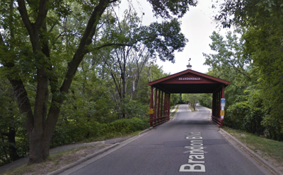
(There must be stories behind this, but I couldn’t find them online. Who, for example, was Brandon?)
The mobile home community is pretty large. It’s also unusually attractive. We visited briefly, some permanent homes were being built. I think it’s going to go upscale — which won’t always go well for the current residents.
Google sent us along a creek trail that goes up the right (east) side of Brandondale …

If you look at the covered bridge entrance to Brandondale (see above) the small hidden trail (44°48’23.7”N 93°35’00.4”W) to the left goes down to the East Creek Hiking Trail in Chaska, a broad multi-use trail that’s mostly paved with short stretches of dirt or gravel. A trail that appears to be completely undocumented online.
Panoramio, which will close shortly, had some trail photos uploaded by Steven Pfeiffer. I assume he lives nearby …

The East Creek trail may be undocumented online, but Google knows of it. When I asked the way to Steiger Lake Ln in Victoria MN it started out by sending us along the East Creek Trail. The Creek is a pretty stream. Here is the 3.1 mile trail from 44°48’23.7”N 93°35’00.4”W to 44°49’39.9"N 93°36'55.1"W:

From there we went west and north to Victoria, then back the conventional way. Which was lovely and fun, but not as mysterious.
Saturday, July 1, 2017
The Duluth Traverse Mountain Biking Trail: A guide based on REI's MTB Project and COGGS commentary
In July of 2017 I took my family to the Duluth Traverse. We’re a diverse group, so this took some planning.
I studied the superb work done by the Cyclists of Gitchee Gumee Shores (COGGS) and REI’s MTB Project (Duluth) [1]. And by study I mean a LOT of study. I had a hard time wrapping my head around the relationships of road, trails, interesting sites, places to eat, emergency exit options and the like. So I assembled two booklets about the Duluth Traverse.
By assembled I mean I didn’t write these booklets. I compiled screenshots and text from the MTB Project and Google Maps into booklet form. One covers the enter trail, the other the portion I tackled with my wife and children:
- DuluthTraverseFull.docx (3MB, Microsoft Word)
- DuluthTraverseLesterFamilyRoute.docx (7.3MB, Microsoft Word)
Click the link to download the Word doc. I could distribute as PDF or HTML, but in 2017 every platform seems to be able to render a Word document. And this way you can go the MTB Project site and update it as you wish. The trails are under constant development so you will want to do an updated version.
I expect someone is going to write a real book about this amazing trail system, so do take a look around if you come across this page.
How did the trail go? Well, I didn’t do any harm to my reputation for excess. Maybe if I hadn’t made a wrong turn on the 7 bridges part of Skyline road between Lester Park and Snively we might have done the whole thing, but instead we cut off about 1/4 of our plan and road downhill to the Portland Malt Shoppe. The next day we drove along the route — even the reduced bit we did was an impressive bit of work for a flatlander family. (My wife was heroic.)
I loved Lester Park and I’m hoping I get to do more of the trail system. The Duluth Traverse is a spectacular project. I do have one caveat though. If you are a flatlander you need to make some trail rating adjustments. Basically “dirt road” means “novice”, “novice” means “intermediate”, “intermediate” means “expert” and “expert” means … I don’t know. I wouldn’t go there.
- fn-
[1] If you try this you will discover Duluth’s weather is as severe as its landscape. It was sunny when my weather app said it was raining, and raining when it was supposed to be dry. You need to review the Coggs trail updates to know what’s rideable. They do allow some trails to be used when they aren’t completely dry.
Update 7/18/2019
This sage advice was posted on a Facebook MN Mountain Biking group by Tara R-A:
If you are the XC type Mission Creek is your best bet or the Duluth Traverse.
If you prefer a climb followed by descending, then start at the base of Lester, climb up Lester River Trail, continue up Hawk Ridge to Morningside, turn around and descend Morningside and Hawk Ridge and continue down on Amity East or West.
If you like more of a technical challenge with lots of rocks, Brewer is a great loop. Park off Haines Road, go through the tunnel under Haines Rd to Lollygagger, do the Homebrew loop and then either go farther on Lollygagger or return to car. Across the street is Piedmont, Upper and Lower Stovetop have lots of B-line option.
If you like tech, steeps, jumps and drops then any of the black and double black descents off Piedmont, DM, BOB, Kissing Booth would be good choices. Having said that the double blacks are legit double blacks and most have no B-lines.
I would also say the blacks in Duluth are harder than any in the metro.
Subscribe to:
Posts (Atom)