Saturday, May 6, 2023

Utepils BrewPub Sunday Rides (Updated)

In our weird post-web post-blog world Utepils brewpub (225 Thomas Ave N #700, Minneapolis, MN 55405) ride information is only available on a Facebook group. They do a ride most Sunday mornings weather permitting. The groups may vary depending on rider volume and leader availability but there's usually a Rec level group for both road and singletrack. In winter there are often 2-3 groups for fat bike rides.

Here's the Facebook description as of May 2023, emphases mine.

As you can see below, we are putting where each ride will be gathering in the parking lot prior to each ride. This will help alleviate the joy of everyone trying to cross paths with their bikes as each ride departs.

We are implementing a few new rules this year. No Burleys, trailers, or pets on rides this year except for the designated Burley rides we will be doing occasionally throughout the year. The groups are getting too big and it creates a difficult environment to maintain. Cargo bikes are allowed and in Rec ride only. If bringing a kid in a cargo bike, please have an enclosed seat for the child. E-BIKES: Only ride in a group you could normally ride in/be comfortable in with a non-motorized bike. E-Bikes allow any rider to jump into any one of our rides. But that does not mean the rider has experience with a paceline or comfort with reaction times. Helmets always required!

PARKING: If you are driving in, please park on the street or in the upper lot nearest Glenwood and bike down to the parking lot. Between yoga also starting at 10am and the brewery opening at 11am, there simply aren't enough parking spots.

BIKE PARKING: You are always ok bringing your bike back to the patio if you do not have a lock/ability to store your bike in your car after the ride. However, we cannot lean then against the fence and block the rear walkway anymore. Utepils is instructing us to bring our bikes to the back of the patio in the lower bowl area and park our bikes back there.

Key info:

Meet at Utepils Brewery at 9:30/9:45am

Announcements start at 9:55am

Rides begin at 10:00am

Waiver link (must be signed once per calendar year): https://forms.gle/7uWwCeJ6ShsYbHv27

ROAD RIDES

Sport (Bay 1): 20-21 mph paceline with minimal stops. 30-35 mile route

Sport Light (Bay 3): 18-20 mph paceline with minimal stops. 25-30 mile route

Sport Ultra Light (Bay 5): 16-18 mph paceline with a few stops. 20-25 mile route

Rec (Parking spots nearest tracks): 11-14 mph group ride. 15-20 mile route

MOUNTAIN BIKE RIDES

Sport (Retaining wall): Have experience mountain biking and can handle majority of obstacles in Theo/Loppet trail systems

Sport Light (Office building): Know what you are doing but not trying to set any speed records

Rec (Auto shop): Newer/want to go at a more casual pace. Comfortable on some obstacles

Wednesday, August 24, 2022

Sherman Lake and Rice Creek Chain of Lakes singletrack (near Lino Lakes)


The above image shows both the Rice Creek and Sherman Lake singletrack trailheads and some parking spots. The Centerville Boat Launch parking comes with a $7 vehicle fee.

These trails were new in 2022. I did them with some young novice riders and they worked well. The overall system is larger than it looks and mixes a new modern flow trail area with legacy singletrack and many bandit trails. As of May 2023 they are not yet in Trailforks but the Sherman Lake section is in MTB Project, they have a MORC page (I think map is from MTB Project so only shows Sherman Lake today), a Trailbot entry as "Rice Creek Chain of Lakes" and a Facebook Page. There's a Facebook Group for volunteers.

Now Bikes (Arden Hills?) runs a semi-regular Sunday morning ride from the Rice Creek Elementary parking lot (The pedestrian bridge is technically closed for repair summer 2023).

Trail info: https://www.alltrails.com/trail/us/minnesota/rice-creek-chain-of-lakes-mountain-bike-loop

Description: https://www.anokacounty.us/DocumentCenter/View/21084/Rice-Creek-Single-Track-Trail

"many miles of trails in at least five different nodes of the park. The trails are heavily wooded and surrounded by lakes. There are sections where biking or hiking on paved trails is required to get to the next node."

Official trailhead per Google Maps: 45°09'47.7"N 93°06'16.4"W. I've never parked there however.

We park at the Kelling woods: 45°9′48″ N  93°6′43″ W entrance. Follow the old dirt road past the closed gate (to keep out cars) and go straight on. It's a pleasant fun trail that branches to some bandit trails but keep going straight and come out on the paved trail. Turn left and in a short time you come to a purpose built system. It's flowy and loopy with some good starter climbs. I recommend two laps. Although it's a green novice trail it does have an optional gap jump!

If conditions are dry you can park just a bit to the west at the Rice Creek Canoe Launch. There's a winding trail that will also take you to the formal system. I actually prefer this route but it's often quite wet and even underwater in places. So only good on dry days.

Some comments from a 2022 Facebook post:

There is another terrain park on the other side of the golf course. Following what is labeled as F Street on the map (actually all bike trail), the other terrain park is between Centerville lake and Sherman lake. There are also 5 single track trails between the 2 terrain parks. I make a loop from my house to hit the 7 features and takes about 1.5 hours, about 12 miles.

And a map from the same post by David L (ride recording)


Update 6/15/2023 from a Facebook thread:

Sean Berry (trail steward):
The Rice Lake Singletrack can be accessed from Aqua Lane, riding the paved trail south to the trail entrance on your left, which is well marked and has a gate and signage. If you get to the long pedestrian bridge, you’ve gone too far south.

You can also access it by going north from Rice Lake Elementary School (575 Birch St, Lino Lakes, MN 55014), over the pedestrian bridge, and another quarter mile or so north: it would then be on your right

Anonimo M:

... park at Laurie Lamotte Park, plenty of parking and easy to get to from 35e. Follow the paved trail around to the Sherman lake trails (0.6 miles) … take the bandit trails to the other trails by Aqua lane.


Update 9/17/2023 - Sherman Lake

Today a friend and I got to the Sherman Lake trail. We parked at the boat launch; there's a $7 vehicle charge to enter the park but entry is free on a bike.


The coordinates of the trailhead are: 45°09'24.3"N 93°04'05.5"W, https://maps.app.goo.gl/AKzdeEib8byWsPjD8.

The trail is about 1.8 miles and it's now my favorite child and novice trail in the metro. The pine forest smells great, looks great, and has a nice view of one of the lakes. It's a flowy trail that's well maintained and fun for anyone to ride but especially inviting to beginning riders. My next novice recommendation is the neighboring Rice Creek singletrack. Then Carver in Woodbury and Salem Hills near Inver Grove.

Monday, July 4, 2022

Two 40 mile ride variations on riding Minneapolis metro

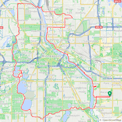
This weekend I did two separate 40 miles rides with different friends. Both were excellent and there are opportunities to combine them to create new routes.

The first ride was supposed to a rerun of a 30 mile ride but I zigged where I was supposed to zag so it was different but also a lot of fun. It was about 40 miles - ridewithgps.com 95373242.

Comments on this route:

1. Minnehaha trail surfaces are a bit rough in places but not bad.

2. We made some false turns trying to get around a detour south of Cedar Lake but they did lead us to a Cedar Lake beach I'd never seen (and that looks like a great place to launch a canoe).

3. The section just across the river east of the Victory Flagpole is confusing on the map, but just follow the trail that starts south along the river, it quickly goes east.

4. Deming Heights park is start of a good climb. There's a cheat to bypass by going a few blocks north and returning after the hill.

5. I misread my phone map when I made the right turn onto 29th ave. I really wanted to head south on NE Arthur street parallel to Stinson (Stinson has too many cars). It did lead me into a quite interesting approach to NE Minneapolis though.  From NE MPLS we entered the river road north of where the bike trail starts; if I did that section again I'd go a bit south on quiet streets so we entered at the bike trail start.

6. I love the little known (and quite expensive) trail that starts at the UMN rowing facility and ends with a fun climb up the bluff.

The second ride (ridewithgps.com 40068258) included a Saint Paul Great River trail favorite (drop down to Yacht Club) then took the river to Greenway and did a city look, then over to Como Park and south on the under appreciated Grigg's north-south route.

We did close to 40 miles. There was minimal overlap with yesterday's 40 miler [1] with Penny and Matt but there are lots of variations one could make combining the two. A few observations...

1. This was entirely on car-free trails/transitway or pleasant low traffic streets. Incredible to be able to do that across two metro areas. MSP rocks.

2. Excluding a few short stretches the trail surfaces were excellent (Greenway restored! Great River lovely. Mendota bridge amazing!) and the multi-million dollar bike bridges are a miracle. Thank you government.

3. I did not see the homeless encampments we had grown accustomed to.

4. We had to work to pass people with motors :-).

5. Como trail is a game changer for east-west travel and creating fun routes.

6. The UMN transit way is an amazing heads-down on-the-drops hammer stretch that zooms across the industrial metro (and connects to Como trail).

7. The detour around light rail construction to get to Cedar Lake and Theo goes through a neat neighborhood and over the Cedar-Isles channel. I need to schedule a weekend for Emily and I to paddle there.

8. Utepils is a good stop on this route (but no food truck today).

9. I learned the route from Utepils into MPLS around the baseball field to the river from a Utepils rec ride. It's a great trick, note the left turn into the MPLS farmer's market.

Sunday, June 19, 2022

Family ride: Southwest Saint Paul to Como Park Pavillion

[Dang, realize I wrote the same post a year ago! This version has more detail.]

After several iterations this is the best route I've come up with for getting from Southwest Saint Paul (Macalester-Groveland, Highland, etc) to Como Park Pavillion (and the relatively new Como trails):

This route has minimal elevation changes and is safer than other North-South routes I've tried. It's about 5 miles. Some notes along the way:
  • Cross Snelling at Jefferson, need the light for a family
  • Then immediately go north to Stanford because the Jefferson bike route sucks
  • Left on Syndicate, then Summit to get across Ayd Mill, then N on Griggs
  • Keep going north through Dunning playground, the bike path goes to a secret bridge over 94
  • Then Griggs again to right on Van Buren (Blair also good) and left on Dunlap. 
  • Right on W Seminary (Englewood works too) and left on Lexington bike path (it's nice here). Follow bike path to Como. (If you want just cross Como heading North then take the bike path that goes north (don't cross Lexington) -- it goes underneath Lexington in a bit.

Saturday, May 28, 2022

MSP Inline Skating - MNSkate

The Minnesota Inline Skate Club does a regular Thur skate. They have a Facebook Group and a dedicated web site. I'm a longtime skater with them though it's been hard for me to make skates this year.

MNSkate is a Facebook only Group that does skates most Mondays. It can be hard to figure out their Facebook Group info (this is a Facebook issue, especially on mobile) so I'm excerpting some info here. It's Current as of May 2022.
Most of their skates start at 6pm. There's often a Facebook post about skates and the calendar also has starting locations.

Friday, May 20, 2022

The MSP Mississippi river bottom trails

(First published 2015, updated May 2020 and May 2022. I haven't updated all of the original text, but check out the 2020 map links at end.)

Just a quick orientation note on the rather confusing system of interrupted mountain / gravel bike / trail running system more or less along the Mississippi river north and south of I 494. More to come later. For this orientation I’m using River coordinates — so imagine river actually runs N/S and, going N, the left side is always the West bank, right side always East bank. Part of the confusion surrounding these trails is some people use compass north/south and some use river coordinates.

Fort Snelling State Park doesn’t easily connect to the trail system, there’s a large gap on the west bank due to airport and military zone that’s unlikely to close, to connect you need to climb the bluff and take the I-494 walkway trail to get to the East bank.

From Upper Fort Snelling (or lower park if climb) you can take Mendota bridge to trail that runs along East bank from Sibley House south to 494 (confusingly called the Fort Snelling State Park River Bottoms trail, but it’s easiest to get to from Fort Snelling proper, not the lower State Park or to cross the river to Sibley House area.)

A mile or so south of Fort Snelling State Park (you can’t get there thanks to restricted military/security zone), on the West Bank, south of 494, there’s a state park visitor center. From that you can do a loop along west bank that crosses at 77 to east bank and returns on 494 — this includes par of the east bank trail. (There used to be an unofficial way to get from near this visitor center to the next trail south on west bank, but I don’t know if that works now.)

From Old Cedar Ave (9500 Old Cedar Ave South, 55425) you can connect up with 2 trails on the west bank, one runs north, the other south. This is often called the Bloomington Ferry Road Access Point or “west end” (it’s on west bank) entry point, and this is the trail MORC describes as “Minnesota River bottoms” (though it’s really just one segment).

As of May 2020 more frequent flooding has made the trail sandier. Some stream crossing have been washed out or are out for repair (including the famed raft).

See also:
Update 2020 from a Facebook Group post:
Update 2022

A 17-18 mile segment that leaves from parking near Gideon House. It's a relatively new park in 2022, not even well labeled in Google. Has great parking until 10pm. In 2022 the raft is in great shape.


Friday, April 22, 2022

St Paul Gravel Rail Trails

These take advantage of some gravel along rail trails and some sandy trails. It's a route for wet weather or other conditions where we can't ride dirt. 

The reference St Paul gravel trail. It's about 25 miles.

The one I did because a train blocked part of our plan. About 22 miles.