The Minnesota river trail is going to change. Major parts will become a paved trail. This means a lot more people will appreciate the river, but the trail many love to run and ride is going to change.
So I’m glad Ben and I got to ride some of the best parts — on a sunny and pleasant November Saturday.
The trail we took is part of a large system along the Minnesota river (save JPEG locally to view). Our Long Meadow Lake section is at the top left of this map:

Basically we did the bottom half of the Long Meadow Lake Unit Trails. Note the blue in the picture below. That’s important! If you end up on the wrong side of the marsh you can’t get back to your entry point. So be careful, the trails are not well marked!
The
MORC trail map Google Version provides the best overview for a mountain biker:

For Minneapolis and Saint Paul residents the traditional approach to the trail is to take bikes on light rail to the Mall of America, then ride a short distance to the yellow/orange entry trails towards the upper right of the screenshot (enters near
Bass Ponds Parking, 44.845976, -93.232640). [Update 2022: I think to do this you'd need to ride through the bird sanctuary! I doubt that actually bothers the birds but we aren't allowed to do that.]
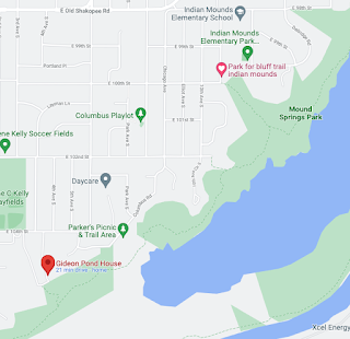
Unfortunately Center Point Energy is replacing a natural gas pipeline along the “bluff trail”, so we entered at the Blue “A” icon by Mound Springs Park, just south of Indian Mounds Elementary (11th Ave S,
44°49’23.6”N 93°15’33.1”W). From there we road to 9 mile creek, marked by the blue sailboat icon. You can
see our route on Strava.

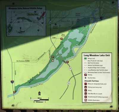
The
Minnesota Valley Long Meadow Lake Unit Trail Map is a good guide to other entry points. The
Old Cedar Ave parking area on that map, unfortunately, is cut off by construction. We really entered at the best site available today. From this point downstream the trail is closed.
It’s easy to park on the street by the entrance here — there’s lots of room in November. There’s a sign saying you can also park at the school nearby.

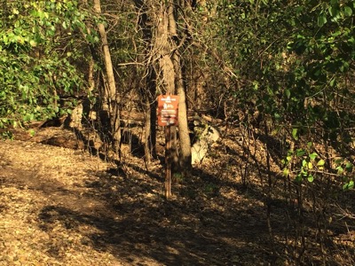
From this point the trail descends smoothly and joins a creek. We stayed to the left at the first fork…

When you’re zooming down it’s very tempting to just try to run a rock pile put in place to manage erosion. These are not friendly rocks. They are rough concrete irregular slabs that are very painful to land on. I recommend walking.

That’s about it for the tricky part of this entrance. The trail is pretty easy to pick up further down the stream.
The trail has lots of forks and branches; heading upstream there are many entrance trails joining from the right. These can be confusing on the return — it was useful to be using Strava so we could retrace our trail. Parts of the trail are narrow and seem almost natural — I bet this was an Indian walking route once. There are also bridges and ramps and wood sections, some very old and some brand new. There are concrete and steel picnic tables in the woods that could be 30-40 years old.
It’s a multi-use and bidirectional trail, so be extra-polite to walkers and runners and watch for oncoming bikes. It’s very pretty in the Fall, and presumably year round …

I think this might be the treacherous trail branch point a friend warned me of — go right and there’s no way back to where we started from “On the return, where the the blue/green trails split, there is a critical branch. If you miss this turn on the return route - easy to do if you ignore the trail going left away from the river and continue straight - you will NOT be able to get back to where you started from”.
You’ll come across this when you return, not long after reentering from the parking lot by 35E.
The Long Meadow Lake Trails end at 35W. But don’t stop there. Continue along the river, following a dirt service road. If you stay by the river it turns back into a trail. After a mile or so you come to one of the gems of the Twin Cities —- the famous 9 mile creek crossing:

As you can see there are two ways to cross. One is by raft, the other, upstream a bit, is by tree trunk with added steps: [In 2020 this was lost years ago - tragically removed by bad people.]

Yes. Someone did this. Presumably many someones. The raft is a serious piece of well maintained kit with heavy ropes. I don’t think it’s Fish and Wildlife, though they must tolerate it. It’s a legend and one must bow in respect. I took the ferry over the creek then carried my bike over the tree. I know people who ride the tree and rails, but I do not think I will ever have those skills.
Then we headed back. Next time I’ll do more loops, this time I used Strava to confirm I was retracing my route correctly.
I’m looking forward to going further next time. In winter there are Fat Bike meetups along this trail…
PS. When I was putting this blog post together something caught my eye where the stream we entered by meets the river:

That little round circle, on close magnification, may have a sort of jumping board on it. I think it’s a local swimming hole…
Update 5/24/2020: I added some modern maps to my
2015 post on the river bottoms. They really help out.
Update 11/25/2020: Further downstream, at the Nature reserve by 494, you can take the 494 bike path over the MN River and across Gun Club Lake, then on the south side of Gun Club take a dirt path exit and double back over the lake under the bridge and catch the Mendota Trail. Some images here
from Facebook, and a description from there that I've edited a bit ...
If you're coming from Bloomington you first take paved 494 bridge ped/bike trail over the MN river until the concrete bridge bridge railing ends. It's not marked but at that point you can see a well worn dirt path entrance. There's a short relatively steep and a bit rocky drop (easy to walk if you prefer) then an easy broad trail that turns into a dirt access road. The path goes under the bridge, then it curves back along (under) the edge of the eastbound 494 elevated roadway. You proceed to ride under the edge of the bridge until you get to the MN River channel, and then turn left (to Cedar) or right (to Mendota).
Update 2/21/22: In the above I entered by Indian Mounds school. Another place to enter is by Gideon Pond House (below). The later option can be good if one is going to ride past 9 mile creek all the way to Bloomington Ferry and you need to shave a bit off the route.