Dedicated bike path along river to 65th & Concord, then it goes along next to Concord to Kaposia Landing trailhead.
Follow the (MRT) trail some miles, eventually turning on Cahill, which takes you to Inver Grove Trail (road). Follow the bike trail along there past the Pine Bend School, & the trail turns away from the road again past the RR trestle. [easy to spot because there's an attractive awning over the trail to protect from train debris] ... After that, the trail follows Courthouse Blvd. a bit before turning off on to a dedicated, removed bike path again ...... the current trail ends near the beginning of Pine Bend Trail (which is a road, not a bike trail - nice shoulder, very low traffic). You can take Pine Bend for a mile or so ... turn Left on Fahey Ave (gravel, may not be signed or may say archery range). Take that a few hundred meters to the Fahey Ave Trailhead (well signed, cars parked, cyclists gathering, Q248+F3). From there follow the trail to Hastings. (The trail does not appear on Google Bicycle routes, I don't think Google is updating those.)
WARNING
Another member shared their Strava map (125 miles - beyond me):These are lovely bike trails, but the Kaposia trails cross roadways. Drivers may turn left or right off Concord without looking for pedestrians, much less a cyclist heading downhill at 30-45mph. (Like someone who didn't see spot the road crossing until they passed in front of a car that turned abruptly left without signaling but a miss is a good as a mile they say).

Another one:

By comparison here are the parts Google knows about:
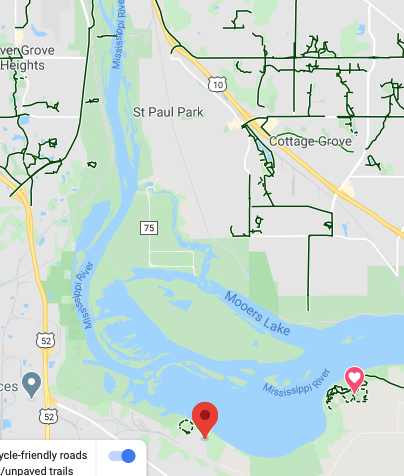
There's a trail from the red marker at bottom to the heart icon in Hastings but Google doesn't know anything about the trails that tracks the green space to the east of 52.
Update 9/20/2020
A friend and I finally did this route. We started from the Harriet Island riverboat parking, it was about 30 miles each way.
The usual start of the route is to go up Wabasha to Concord then join the river trails by Kaposia landing. From that point until our lunch at The Onion in Hastings we did not travel with a single car.
This is a great trail, but in 2021 it will get much better. There will soon be a bicycle trail, traffic free, from Harriet Island park to Hastings (not to mention trails through Lilydale upstream that track along the Minnesota river, and trails from Hastings downstream [1]). The problem of the St Paul airport will be solved.
The new trail, unopened but almost complete, was tracked by a scofflaw friend of mine:


- fn -
[1] Local cyclist: "From Hastings there’s a trail that goes over the Highway 61 bridge and goes out to Prescott. There’s also a trail that goes south from Hastings over the Vermillion River and heads back West along the South side of the Vermillion River."
Update 4/4/2021:
There's a proper map available:

The red segment is not a problem, there's a quiet road there not shown on the map. Since this map was created (2020?) the extension at north to Harriet Island has been opened.
1 comment:
This is a great trail that I have ridden as a loop about a dozen times. The section from the heart to the red icon opened late 2016 I believe. The most recent addition is a segment that gets you past flint hills near hastings, this opened in 2019. There is still another new section planned to link from the archery park to hastings, however this is totally rideable on the road (Pine Bend Tr). https://www.co.dakota.mn.us/Transportation/PlannedConstruction/MRRTRosemount/Pages/default.aspx
Post a Comment