My buddy Scott and I went for a well known local ride west of Minneapolis. Along the way we found a short but novel trail. This post is about that.
goo.gl/maps/JnaUFyeaHcp was the original plan for today, but goo.gl/maps/y75kHLRozQU2 is what we more or less did:

As is often true with a bike trip of this length construction and detours and trail closures (2014 flood and 3 years of court battles have knocked out part of the LRT South trail) and my funky Google waypoint-generated maps sometimes took us off route. One of those diversions was to an undiscovered country.
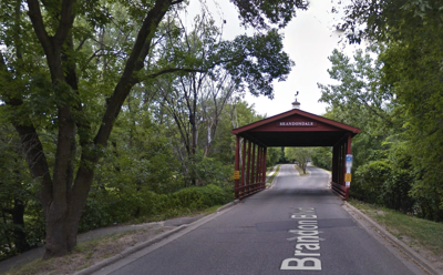
Google sent us on an obscure journey starting at Brandondale Mobile Home Park (Rule generated web site). The entrance to the large park is marked by a covered bridge:
(There must be stories behind this, but I couldn’t find them online. Who, for example, was Brandon?)
The mobile home community is pretty large. It’s also unusually attractive. We visited briefly, some permanent homes were being built. I think it’s going to go upscale — which won’t always go well for the current residents.
Google sent us along a creek trail that goes up the right (east) side of Brandondale …
If you look at the covered bridge entrance to Brandondale (see above) the small hidden trail (44°48’23.7”N 93°35’00.4”W) to the left goes down to the East Creek Hiking Trail in Chaska, a broad multi-use trail that’s mostly paved with short stretches of dirt or gravel. A trail that appears to be completely undocumented online.
Panoramio, which will close shortly, had some trail photos uploaded by Steven Pfeiffer. I assume he lives nearby …
The East Creek trail may be undocumented online, but Google knows of it. When I asked the way to Steiger Lake Ln in Victoria MN it started out by sending us along the East Creek Trail. The Creek is a pretty stream. Here is the 3.1 mile trail from 44°48’23.7”N 93°35’00.4”W to 44°49’39.9"N 93°36'55.1"W:
From there we went west and north to Victoria, then back the conventional way. Which was lovely and fun, but not as mysterious.


